JACKSON OWED HIS VICTORY AT HORSESHOE BEND TO CHEROKEE ALLIES WHO SWAM THE TALLAPOOSA RIVER AND ATTACKED THE VILLAGE OF TOHEPEKA FOR MORE INFO
ABOUT THE CHEROKEE CHIEF JUNALUSKA WHO SAVED THE LIFE OF ANDREW JACKSON
AT HORSESHOE BEND CLICK HERE
. A MAJORITY OF THE CREEK VILLAGES IN WHAT BECAME ALABAMA REJECTED TECUMSEH AND WAR WITH THE AMERICANS. THE CREEKS HAD BELIEVED THEY COULD CONTINUE LIVING IN PEACE AND WOULD BE SECURE IN THE POSSESSION OF THE LAND THEY FARMED.
.. IN THE TREATY OF FORT JACKSON, JACKSON" BETRAYED" THE INDIANS: CREEK, CHEROKEE AND CHOCTAW WHO HAD GIVEN HIM VICTORY. THE CHOCTAWS PARTICIPATED IN THE DEFEAT OF THE BRITISH IN THE BATTLE OF NEW ORLEANS.
At New Orleans Jackson ENSURED HIS RISE TO THE PRESIDENCY AS A CHAMPION OF THE WESTERN FRONTIERSMEN WHO COVETED THE RICH LANDS WHICH THE INDIANS OCCUPIED IN Georgia, Alabama and Mississippi.. JACKSON'S SOLUTION WAS-THE INDIAN REMOVAL ACT OF 1830
Passed into law during Jackson's second year as President, this Act set the tone for his administration's handling of all Indian affairs. In fact, Removal outlasted his tenure: the last of the Cherokee were infamously forced on the Trail of Tears death march in 1838, two years after Jackson's second--and final--term ended.
Though all Eastern tribes were eventually relocated West of the Mississippi, the government failed utterly in its pledge to enact the policy on a strictly voluntary basis (a policy notably not written into the act.) Nearly all relocation was carried out under duress, whether by military escort, or when no other option remained after tribal decimation by broken treaties, fraudulent land deals and the wars these often caused. Here is the Act's preamble:
CHAP. CXLVIII.--An Act to provide for an exchange of lands with the Indians residing in any of the states or territories, and for their removal west of the river Mississippi.
- Indian Removal Policy
Developing & Applying the Removal Act
Andrew Jackson Addresses Congress.
In seven of his eight annual messages to Congress, US President Andrew Jackson devotes several paragraphs to the policy of Indian removal (without ever mentioning the Indian Removal Act of 1830 by name), along with other oblique references to the perception and treatment of aboriginal Americans. To a certain extent the Indian issue defines his Presidency; no other policy spans Jackson's entire eight-year term with such a steady concentration of resources.
Being a British Columbian, living in a Canadian province still struggling with both its Indian affairs legacy and its present relations with its aboriginal inhabitants, what disturbs me most when reading these documents is just how little our language for discussing these issues has changed in 170 years, how subtly and insidiously ingrained the patterns of thought apparent in these messages remain in our present culture.
- First Inaugural Address, March 4, 1829
- In which Jackson reassures the Indian tribes that their treatment under his administration will be liberal, just and in accordance with the beliefs of the American people:
"It will be my sincere and constant desire to observe toward the Indian tribes within our limits a just and liberal policy, and to give that humane and considerate attention to their rights and their wants which is consistent with the habits of our Government and the feelings of our people." -- Andrew Jackson
- First Annual Message to Congress, December 8, 1829
- In which, in the closing paragraphs of the speech, Jackson lays out his policy for relocating Indians of the east to territories west of the Mississippi. This policy becomes law as the Indian Removal Act by his next annual address. An excerpt from the speech:
"Our conduct toward these people is deeply interesting to our national character. Their present condition, contrasted with what they once were, makes a most powerful appeal to our sympathies. Our ancestors found them the uncontrolled possessors of these vast regions. By persuasion and force they have been made to retire from river to river and from mountain to mountain, until some of the tribes have become extinct and others have left but remnants to preserve for awhile their once terrible names. Surrounded by the whites with their arts of civilization, which by destroying the resources of the savage doom him to weakness and decay, the fate of the Mohegan, the Narragansett, and the Delaware is fast overtaking the Choctaw, the Cherokee, and the Creek. That this fate surely awaits them if they remain within the limits of the states does not admit of a doubt. Humanity and national honor demand that every effort should be made to avert so great a calamity." -- Andrew Jackson
- Second Annual Message to Congress, December 6, 1830
- Jackson announces Indian Removal nearing consumation; the Chocktaw and Chickasaw peoples agree to relocation; this development will induce other tribes to follow; states his good-will toward aboriginal people;
"Toward the aborigines of the country no one can indulge a more friendly feeling than myself, or would go further in attempting to reclaim them from their wandering habits and make them a happy, prosperous people." -- Andrew Jackson
- Third Annual Message to Congress, December 6, 1831
- Funds are appropriated for the removal of eastern tribes; treaty negotiation for actual removal of the Choctaw and Chickasaw underway; Cherokee registration in Georgia recommences with hopes of up to two-thirds participation; removal efforts concentrated in Ohio and Indiana where treaties extinguished all Ohio reservations; philanthropists and missionaries invited to help removed Indians advance "from barbarism to the habits and enjoyments of civilized life."
"It is pleasing to reflect that results so beneficial, not only to the States immediately concerned, but to the harmony of the Union, will have been accomplished by measures equally advantageous to the Indians. What the native savages become when surrounded by a dense population and by mixing with the whites may be seen in the miserable remnants of a few Eastern tribes, deprived of political and civil rights, forbidden to make contracts, and subjected to guardians, dragging out a wretched existence, without excitement, without hope, and almost without thought." -- Andrew Jackson
- Fourth Annual Message to Congress, December 4, 1832
- Substantial deficit reduction despite Indian 'removal and preservation' costs; oblique reference to economics of converting Indian land first to public land, then selling parcels to settlers at cost; Sac and Fox uprising put down -- disaffected tribes 'dispersed or destroyed'; the 'wise and humane' Indian removal policy is steadily pursued and approaching consummation -- Secretary of War reports; Georgian Cherokees resist removal.
"After a harassing warfare, prolonged by the nature of the country and by the difficulty of procuring subsistence, the Indians were entirely defeated, and the disaffected band dispersed or destroyed. The result has been creditable to the troops engaged in the service. Severe as is the lesson to the Indians, it was rendered necessary by their unprovoked aggressions, and it is to be hoped that its impression will be permanent and salutary." -- Andrew Jackson
- Fifth Annual Message to Congress, December 3, 1833
- Survivors of Sac and Fox War of 1832 removed west of Mississippi; 'inferior' Georgian Cherokee continue to resist 'force of circumstances' and refuse removal; Jackson reiterates removal and 'political reorganisation' form the best and only option for continued existence of eastern Indians.
"My original convictions upon this subject have been confirmed by the course of events for several years, and experience is every day adding to their strength. That those tribes can not exist surrounded by our settlements and in continual contact with our citizens is certain. They have neither the intelligence, the industry, the moral habits, nor the desire of improvement which are essential to any favorable change in their condition. Established in the midst of another and a superior race, and without appreciating the causes of their inferiority or seeking to control them, they must necessarily yield to the force of circumstances and ere long disappear." -- Andrew Jackson
- Sixth Annual Message to Congress, December 1, 1834
- Military blocks 'inroads' of Western frontier Indians; Creek removal imminent, Seminole next, Cherokee stubbornly refuse against own best interests; Indian Trade and Intercourse Acto of 1834 made law, restricting treatied sovereignty of Western Indians.
"I regret that the Cherokees east of the Mississippi have not yet determined as a community to remove. How long the personal causes which have heretofore retarded that ultimately inevitable measure will continue to operate I am unable to conjecture. It is certain, however, that delay will bring with it accumulated evils which will render their condition more and more unpleasant. The experience of every year adds to the conviction that emigration, and that alone, can preserve from destruction the remnant of the tribes yet living amongst us." -- Andrew Jackson
- Seventh Annual Message to Congress, December 7, 1835
- Inexplicably, Jackson makes no direct reference to Indian removal in this message, though it was in this year that the Seminole were ordered to leave Florida. In fact, the only reference to native issues is made obliquely in a paragraph concerning the sale of public lands, much of which were once treatied Indian territories.
"The extraordinary receipts from the sales of the public lands invite you to consider what improvements the land system, and particularly the condition of the General Land Office, may require. At the time this institution was organized, near a quarter century ago, it would probably have been thought extravagant to anticipate for this period such an addition to its business as has been produced by the vast increase of those sales during the past and present years. It may also be observed that since the year 1812 the land offices and surveying districts have been greatly multiplied, and that numerous legislative enactments from year to year since that time have imposed a great amount of new and additional duties upon that office, while the want of a timely application of force commensurate with the care and labor required has caused the increasing embarrassment of accumulated arrears in the different branches of the establishment." -- Andrew Jackson
- Eighth Annual Message to Congress, December 5, 1836
- Indian wars force massive mobilisation of troops, militia and volunteers; Seminoles refuse to relocate and win early upper-hand in Second Seminole War; Urgent need for further appropriations to 'suppress hostilities;' Creek defeated and relocated West of Mississippi; Cherokee country pacified and secured by ongoing military vigilance; Mexico authorises expeditions to quell Indians beyond US frontier; Commissioner of Indian Affairs suggests larger military presence in Indian country to protect Western frontier from Indians, and the Indians from each other; Jackson prematurely declares Indian Removal to be consummated--Cherokee forcibly relocated two years later in 1838.
"The national policy, founded alike in interest and in humanity, so long and so steadily pursued by this Government for the removal of the Indian tribes originally settled on this side of the Mississippi to the West of that river, may be said to have been consummated by the conclusion of the late treaty with the Cherokees." -- Andrew Jackson
November 29, 1813: Battle of Autosse
December 23, 1813: Battle of Holy Ground (Econochaca)
January 22, 1814: Battle of Emuckfau Creek
A DETAILED ACCOUNT OF THE BATTLE OF BURNT CORN
From the letter of General James Wilkinson, we learn that more than three hundred hostile Creeks, under the Prophet Francis, were camped, on the 25th of June, at the Holy Ground. General Wilkinson writes: "The last information received of their doings was on Wednesday [the 23d of June], by Ward's wife, who has been forced from him with her children. She reported that the party, thus encamped, were about to move down the river to break up the half-breed settlements, and those of the citizens in the fork of the rivers." While this was, no doubt, the real and ultimate design of the hostile Creeks, it was first necessary to put themselves on a thorough war footing by procuring supplies of arms and ammunition from Pensacola.
With this object in view, at some period in the early part of July, a party of Creeks, comprising a portion, if not all, of the hostile camp at the Holy Ground, with many pack-horses, took up the line of march for Pensacola. This party was under the command of Peter McQueen, at the head of the Tallassee warriors, with Jim Boy, as principal war chief, commanding the Atossees,* and Josiah Francis, commanding the Alibamos. Pickett gives the entire force as amounting to three hundred and fifty warriors; Colonel Carson, in a letter to General Claiborne, estimates them at three hundred; but General Woodward, in his Reminiscences, simply states that their numbers have been greatly overrated. "On their way," writes Pickett, "they beat and drove off every Indian that would not take the war-talk. "On their arrival at Burnt Corn Spring, situated at the crossing of the Federal and the Pensacola roads, they burned the house and corn crib of James Cornells, seized his wife and carried her with them to Pensacola, where she was sold to Madame Baronne, a French lady, for a blanket. A man, named Marlowe, living with Cornells, was also carried prisoner to Pensacola. Cornells, it seems, was absent from home, at the time of this outrage. We hear of him, soon afterwards, at Jackson, on the Tombigbee, "mounted on a fast-flying grey horse," bringing to the settlers the tidings of Creek hostilities.
* Pickett in his narrative has here evidently made a slip writing Autaugas for Atossees. H. S. H. The perilous condition of the southern frontier at this period, the early part of July, is well portrayed in the following passages from Pickett: "The inhabitants of the Tombigbee and the Tensaw had constantly petitioned the Governor for an army to repel the Creeks, whose attacks they hourly expected. But General Flournoy, who had succeeded Wilkinson in command, refused to send away of the regular or volunteer troops. The British fleet was seen off the coast, from which supplies, arms, ammunition, and Indian emissaries, were sent to Pensacola and other Spanish ports in Florida. Everything foreboded the extermination of the Americans in Alabama, who were the most isolated and defenceless people imaginable." When Colonel Joseph Carson, commanding at Fort Stoddart, was informed that the above mentioned force of Creek warriors had gone to Pensacola, he despatched David Tate and William Pierce to the town to ascertain the intentions of the Creeks and whether Governor Manique would grant them a supply of ammunition. The information gained by these spies and reported on their respective returns, all summed up, was that the Creeks, on their arrival in Pensacola, had called upon the Governor and presented him a letter from a British general in Canada. This letter had been given to Little Warrior when he was in Canada and at his death was saved by his nephew and afterwards given to Josiah Francis, The Creeks, whether right or wrong, supposed that this letter requested or authorized the Governor to supply them with ammunition. The Governor, in reply, assured them that it was merely a letter of recommendation, and at first refused to comply with their demands. He, however, appointed another meeting for them, and the Creeks, in the meanwhile, made every exertion to procure powder and lead by private purchase. According to Tate's information, which he received from some of the prisoners whom the Creeks had brought down with them, their language breathed out vengeance against the white people and they dropped some hints of attacking the Tensaw settlers on their return. The Creeks finally succeeded in their negotiation with the Governor, who issued an order supplying them with three hundred pounds of powder and a proportionate quantity of lead. To obtain this large supply, McQueen handed the Governor a list of the towns ready to take up arms, making four thousand eight hundred warriors. Even this large amount of ammunition was not satisfactory to the Creeks; they demanded more, but it seems that Manique yielded no further to their demands. The Creeks now openly declared that they were going to war against the Americans; that on their return to the nation they would be joined by seven hundred warriors at the Whet Stone Hill,* where they would distribute their ammunition and then return against the Tombigbee settlers. They now held their war-dance, an action equivalent to a formal declaration of war.
* The hill on which the present town of Lownsoro is situated. Such was the information brought by the spies from Pensacola, and their evidence clearly shows that the disaffected section of the Creek Confederacy was now committed to open war against the Americans. No other construction can be placed upon the words and actions of the agents or representatives of this disaffected section,--the hostile party in Pensacola. We may conjecture that this party left Pensacola about the twenty-fourth of July, but, as will be noticed hereafter, it seems that it was only a part of the force, mainly under the command of Jim Boy that took up the line of march, while the greater party, from some cause, tarried a while longer in Pensacola. A slight incident here, perhaps, is worthy of being placed on record to the credit of Jim Boy. While in Pensacola the Creeks met with Zachariah McGirth a man well known in the Creek nation. Some of the Creeks wished to kill him. But Jim Boy interposed and said that the man or men that harmed McGirth should be put to death In the meanwhile, the inhabitants of the Tombigbee and the Tensaw were in a state of great alarm. Many had abandoned their farms and taken refuge in the forts situated along the Tombigbee and the Alabama. Judge Toulmin, writing from Fort Stoddart, the twenty-third of July, says, "The people have been fleeing all night." This brief sentence clearly reveals the alarm and anxiety pervading the Alabama frontier at this period. Upon the report of the spies from Pensacola relative to the action of Governor Manique and the Creeks, Colonel James Caller, of Washington County, the senior militia officer on the frontier, forthwith ordered out the militia. A force was soon embodied and enrolled under his command. Colonel Caller resolved to intercept the Creeks on their return and capture their ammunition. His command, at first, consisted of three small companies, two from St. Stephens, commanded respectively by Captains Baily Heard and Benjamin Smoot, and one company from Washington County, commanded by Captain David Cartwright. With this force Colonel Caller crossed the Tombigbee at St. Stephens, Sunday, July 25th; thence passing through the town of Jackson, he marched to Fort Glass, where he made a short halt. At this place he was reinforced by accompany under Captain Sam Dale, with Lieutenant Walter G. Creagh as second in command. Another force had also joined him in the expedition commanded by William McGrew, Robert Callier, and William Bradberry. The whole party were well mounted and carried their own rifles and shot guns, of every size and description. Captain Dale carried a double barrel shot gun--an unusual weapon in that day. An eye-witness has described Colonel Caller at Fort Glass as wearing a calico hunting shirt, a high bell-crowned hat and top boots and riding a large fine bay horse. Leaving Fort Glass, the party bivouacked the ensuing night at Sizemore's ferry, on the west bank of the Alabama River. The next morning they crossed the river, the horses swimming by the side of the canoes. This occupied several hours. They now marched in a southeastern direction to the cowpens of David Tate, where a halt was made. Here Colonel Caller received another reinforcement, a company from Tensaw and Little River, commanded by the brave half-breed, Captain Dixon Bailey. The whole force, composed of white men, half-breeds and friendly Indians, now numbered one hundred and eighty men, rank and file, in six small companies. From the cow-pens they marched to the intersection of the Wolf-trail and the Pensacola road, at or near the site of the present village of Belleville, in Conecuh County, where they camped for the night. The next morning, the twenty seventh of July the command was reorganized. William McGrew was chosen Lieutenant Colonel, and Zachariah Phillips, McFarlan, Wood, and Jourdan were elected to the rank of Major. It is stated that this unusual number of field officers was made to satisfy military aspirations. The command now took up the line of march down the Pensacola road, which here ran, and still runs, parallel with Burnt Corn Creek. About eleven o'clock the spies returned at a rapid rate and reported that they had found the enemy encamped near Burnt Corn Creek, a few miles in their advance, and that they were busily engaged in cooking and eating. A consultation of the officers immediately took place, and it was decided to take the Creeks by surprise. The troops were thrown into three divisions, Captain Smoot in front of the right, Captain Bailey in front of the centre, and Captain Dale in front of the left.
As the descriptions of the Burnt Corn battle ground given by Meek and Pickett are somewhat vague and inaccurate, a more correct account of the topography, gained from personal observation, is here given to the reader. Burnt Corn Creek, near which the battle was fought, runs southward for several hundred yards, then making an abrupt bend, runs southeastward for half a mile or more. Right at the elbow of the bend is the crossing of the old Pensacola road. The low pine barren enclosed in this bend--not a peninsula as called by Pickett--is enveloped by a semicircular range of hills, which extends from the creek bank on the south some half a mile below the crossing, and terminates on the west at the bank, some three hundred yards above the crossing. This western terminus is now locally known as the Bluff Landing. The Pensacola road from the crossing runs northward some two hundred yards, then turning runs eastward half a mile, making a continuous and gradual ascent up the slope of the hills, and then again turns northward. The spring, now known as Cooper's Spring, is situated about half a mile nearly east of the crossing, and about one hundred and fifty yards south of the road. It gushes forth at the base of a steep hill and is the fountain head of a small reed-brake branch, which empties into the creek about two hundred yards below the crossing. The hill, at the base of which the spring is situated, is about the centre of the semicircular range of hills which envelops the pine barren.
About sixty yards northwest of the spring, between the spring and the road, is a comparatively level spot of land, about an acre in extent. This spot, we conjecture, was the Creek camp, or at least where the main body was encamped, as it is the only place immediately near the spring suitable for a camp. The hill here rises steep and abruptly to the northeast, and a hostile force could well approach and charge down this hill within close gunshot of the camp before being seen. This locality famed as the battle ground of Burnt Corn is in Escambia County, one-half a mile from the line of Conecuh County, on the north. As reported by the scouts, the Creek camp was near the spring, and their pack-horses were grazing around them. No rumor of the foe's advance had reached their ears; all were careless, off their guard and enjoying themselves, for good cheer was in the Muscogee camp. Their martial spirits, as we may well imagine, were not now stirred by thoughts of war and bloodshed, but were concentrated on the more peaceful delights of cooking and feasting, the pleasures of the pot, the kettle, and the bowl. The Burnt Corn battlefield was in the unorganized part of Mississippi Territory (in the Indian country proper) in the year 1818. Monroe county organized in 1815, included Burnt Corn. In 1818 the same locality was in Conecuh county established that year. Now it seems, it is in Escambia county, established in 1868 although Brewer, writing in 1872 still places the battle ground of Burnt Corn in Conecuh. (The following cut will give some idea of the locality).
Colonel Callers troops, as we may conjecture, must have turned to the left, off the road, perhaps near the Red Hollow, about a mile distant from the spring, and thence approached the Creek camp from the northeast and east, as from the nature of the country this was the only route they could have taken so as to surprise the Red Stick camp.* The troops moved cautiously and silently onward until they reached the rear of the hill that overlooked the Creek camp. Here, Pickett says, they dismounted; but Meek says the main body dismounted; yet neither Pickett nor Meek makes any statement as to the disposition of their horses--whether they were tied or were consigned to the care of a guard, or whether each trooper, as he dismounted, left his horse to shift for himself. From the fact that many of the horses fell into the hands of the enemy, one is led to the conjecture that no regular system was employed, but that every man did that which was right in his own eyes. After dismounting, the troops moved silently to the crest of the hill, whence they made a rapid charge down its slope and opened fire upon the Creek camp, as the red warriors stood, sat, or reclined in scattered groups over the ground. The Creeks, though startled by this sudden and unexpected onset, quickly sprang to arms, returned the fire, and for several minutes bravely withstood the charge of the whites, then gave way and retreated in wild confusion to the creek. Early in the fight a Creek woman and a negro man were slain. It is stated that the latter, who was busily engaged in cooking, had ample time to make his escape, but being a slave and non-combatant he doubtless apprehended no danger from the whites. A portion of the troops pursued the Indians to the creek--Meek says they even drove them across the creek into a reed-brake beyond--but we think this latter statement exceedingly doubtful.
While these were performing this soldierly duty, the more numerous party devoted their energies to capturing and leading off the pack-horses. This led to a disastrous reverse. The Creeks in the cane and reed-brakes soon saw the demoralization of the greater part of the whites and the fewness of the assailants confronting them. They rallied, and, with guns, tomahawks and war clubs, rushed forth from the swamp, and with the fiercest cries of vengeance charged upon their foes and drove them headlong before them. Colonel Caller acted bravely, but unable to restore order, he commanded the troops to fall back to the hill so as to secure a stronger position and there to renew the battle. The plundering party, misconstruing this order, and seeing the fighting portion of the troops falling back before the enemy, were now seized with a panic, and fled in wild confusion, still, however, notwithstanding their terror, driving their horses before them, some even mounting their prizes so as to more quickly escape from the fatal field. In vain did Colonel Caller, Captain Bailey and other officers endeavor to rally them and persuade them to make a stand against the foe. Terror and avarice proved more potent than pride and patriotism, and the panic-stricken throng surged to the rear. Only about eighty fighting men now remained, and these had taken a stand in the open woods at the foot of the hill. Commanded by Captains Dale, Bailey, and Smoot, they fought with laudable courage for an hour or more under the fire poured upon them by McQueen's warriors from the cover of the thick and sheltering reeds. The battle may now be briefly described as "a series of charges and retreats, irregular skirmishes and frequent close and violent encounters of individuals and scattered squads." It was noticed that the Creek marksmanship was inferior to that of the Americans. It was in the fight at the foot of the hill that Captain Dale was wounded by a rifle ball, which struck him in the left side, glanced around and lodged near the back bone. The captain continued to fight as long as his strength permitted, and then threw aside his double barrel into the top of a fallen tree. This gun, we may here state, Dale recovered after the war from an Indian, at Fort Barancas. About the same time that Dale was wounded, Elijah Glass, a twin brother of David Glass, was slain. He was standing behind another soldier, who was in a stooping position, when a rifle ball struck him fatally in the upper part of the breast.
* The hostile Creeks were often called Red Sticks because their war-clubs were invariably painted red. "Red Stick" was considered an honorable appellation, and as such it will occasionally be used in this work. "Red Stick War" is the name by which the War of 1813 is still known among the Creeks of the Indian Territory. H. S. H. The battle now at last began to bear hard upon the Americans. Two-thirds of the command were in full retreat, and no alternative lay before the fighting portion but to abandon the field, which they did in the greatest disorder. Many of them had lost their horses, some of which had been appropriated by the fugitives, and others, in some manner, had fallen into the hands of the enemy, among these, the horses belonging to Colonel Caller and Major Wood. The troops now fled in all directions. Some succeeded in reaching and mounting their own horses; others mounted the first horses they came to; in some cases, in their eagerness to escape, two mounting the same horse; while others actually ran off afoot. It was a disgraceful rout. "After all these had left the field," writes Pickett, "three young men were found, still fighting by themselves on one side of the peninsula, [bend,] and keeping at bay some savages who were concealed in the cane. They were Lieutenant Patrick May, a private named Ambrose Miles, and Lieutenant Girard W. Creagh. A warrior presented his tall form. May and the savage discharged their guns at each other. The Indian fell dead in the cane; his fire, however, had shattered the Lieutenant's piece near the lock. Resolving, also to retreat, these intrepid men made a rapid rush for their horses, when Creagh, brought to the ground by the effects of a wound which he received in the hip, cried out "Save me, Lieutenant, or I am gone". May instantly raised him up, bore him off on his back, and placed him in the saddle, while Miles held the bridle reins. A rapid retreat saved their lives. Reaching the top of the hill, they saw Lieutenant Bradberry, bleeding with his wounds, and endeavoring to rally some of his men." This was the last effort made to stem the tide of disaster.
Two young men were slain in the battle, _____ Ballard and Elijah Glass, both it is believed, being members of Dale's company. Ballard had fought with great bravery. Just before the final retreat, he was wounded in the hip. He was able to walk, but not fast enough to reach his horse, which in the meantime, had been appropriated by one of the fugitives. A few of the soldiers returned and successively made efforts to mount Ballard behind them on their horses, but the Indians pressed them so closely that this could not be done. Ballard told them to leave him to his fate and not to risk their own lives in attempting to save him. At last the Indians reached him, and for some moments, he held them at bay, fighting desperately with the butt of his musket, but he was soon overpowered and slain. Several Indians now sprang forward, scalped him and began to beat him with their war clubs. Two of the retreating soldiers, David Glass and Lenoir, saw this. Glass was afoot, Lenoir mounted. "Is your gun loaded," asked Glass of Lenoir. "Yes," was the reply. "Then shoot those Indians that are beating that man yonder." Lenoir hesitating, Glass quickly spoke, "Then lend me your gun." Exchanging guns, Glass then advanced a few paces and fired at two or three of the Indians whose heads happened to be in a line, and at the discharge one of them fell, as Glass supposed, slain or wounded. This was the last shot fired in the battle of Burnt Corn, which had lasted from about midday until about three o'clock in the afternoon. The Creeks pursued the whites nearly a mile in the open woods and nothing but their inability to overtake them saved the fugitives from a general slaughter. Pickett writes: "The retreat continued all night in the most irregular manner, and the trail was lined from one end to the other with small squads, and sometimes one man by himself. The wounded travelled slowly, and often stopped to rest." Such was the result of the battle of Burnt Corn, the first engagement in the long and bloody Creek War. Most of the Creek pack-horses, about two hundred pounds of powder and some lead was all the success the Americans could claim from this engagement. Their loss was two men killed, Ballard and Glass. Fifteen were wounded, Captain Sam. Dale, Lieutenant G. W. Creagh, Lieutenant William Bradberry, shot in the calf of the leg; Armstrong, wounded in the thigh; Jack Henry, wounded in the knee; Robert Lewis, Alexander Hollinger, William Baldwin, and seven others whose names have not been preserved.
The Creek loss is not positively known. Colonel Carson, in a letter to General Claiborne, written a few days after the battle, states that from the best information it was ten or twelve killed and eight or nine wounded. As to the numbers engaged at Burnt Corn, we know that the American force numbered one hundred and eighty. General Woodward, in his Reminiscences, states, on the authority of Jim Boy, that the Creek force was two-thirds less. He writes. "Jim Boy said that the war had not fairly broke out, and that they never thought of being attacked; that he did not start [from Pensacola] with a hundred men, and all of those he did start with were not in the fight. I have heard Jim tell it often that if the whites had not stopped to gather up the pack horses, and had pursued the Indians a little further, they, the Indians, would have quit and gone off. But the Indians discovered the very great confusion the whites were in searching for plunder, and they fired a few guns from the creek swamp, and a general stampede was the result. McGirth always corroborated Jim Boy's statement as to the number of Indians in the Burnt Corn battle." The above, perhaps, may be regarded, in some measure, as the Creek version of Burnt Corn. If possession of the battlefield may be considered a claim to victory, then Burnt Corn may well be regarded a Creek victory. After the battle, a part of the Red Sticks retraced their steps to Pensacola for more military supplies, and a part returned to the nation. Their antagonists, Colonel Caller's troopers, were never reorganized after the battle. They returned home, in scattered bands, by various routes, and each man mustered himself out of service. About seventy of them on the retreat collected together at Sizemore's Ferry, where, for a while, they had much difficulty in making their horses swim the river. David Glass finally plunged into the stream and managed to turn the horses' heads towards the other shore. After the horses had all landed on the further bank, the men crossed over in canoes.
Colonel Caller and Major Wood, as we have related, both lost their horses at Burnt Corn. As the fugitives shifted, every man for himself, these two officers were left in the rear. They soon became bewildered and lost their way in the forest, and as they did not return with the other soldiers, their friends became very apprehensive as to their safety. "When General Claiborne arrived in the country, he wrote to Bailey, Tate, and Moniac, urging them to hunt for these unfortunate men. They were afterwards found, starved almost to death, and bereft of their senses." When found, Colonel Caller had on nothing but his shirt and drawers. After the war, the Colonel, with some difficulty, recovered his fine horse from the Creeks. But Major Wood was not so fortunate.
Colonel J. F. H. Claiborne, in his "Life of Sam Dale," writes: "Colonel Caller was long a conspicuous man in the politics of Mississippi Territory, often representing Washington County in the legislature. No one who knew Caller and Wood intimately doubted their courage; but the disaster of Burnt Corn brought down on them much scurrility. Major Wood, who was as sensitive as brave, bad not the fortitude to despise the scorn of the world, and sought forgetfulness, as too many men often do, in habitual intemperance."
The battle of Burnt Corn, on the whole, was damaging to the prestige of American prowess. For many years its participants had to endure the ridicule of their neighbors and friends; for it was not considered creditable to any one to claim that he had been a soldier in the Burnt Corn battle. It should here be stated that at the time of its occurrence many of the citizens of Washington County censured Colonel Caller severely for this expedition and believed that he acted too hastily in the matter. They believed that, while putting themselves on a war footing, it would have been better to have made use of conciliatory measures towards the Creeks; that they thereby might have overruled them and perhaps averted hostilities. But this attack by Colonel Caller maddened them and converted numbers of hesitating and neutral warriors into deadly foes, and the massacre at Fort Mims was the result.
NOTES.
In writing the history of the Burnt Corn expedition, the writer has drawn his materials from the following sources: Pickett's History of Alabama, Meek's Romantic Passages of Southwestern History, General Thomas Woodward's Reminiscences of the Creek or Muscogee Indians, letters of Judge Toulmin and Colonel Carson, addressed to General Claiborne, published in the Alabama Historical Reporter of June, 1880, and a letter from Colonel Carson to General Claiborne, published in Claiborne's "Life of Sam Dale." In addition to the above sources must be added conversations with the late Rev. Josiah Allen, of Jasper County, Mississippi, who, perhaps, was the last survivor of Capt. Sam Dale's company. Mr. Allen was not in the Burnt Corn expedition, but was intimately associated with many of the participants in the battle, from whom he derived a number of incidents and other minor facts, which have been incorporated in this narrative The description of the battle ground, as has been stated, is the result of personal observation. H. S. H.
http://www.burntcorn.com/htmlfiles/battle.html

Battles of Emuckfaw and Enotachopo Creeks
Creek War |
 |
DATE: January 22-24, 1814
LOCATION: Emuckfaw and Enotachopo Creeks, Alabama (Mississippi Territory)
VICTORY: Inconclusive
COMMANDERS: Col. Andrew Jackson (American)/ unknown (Indian)
CASUALTIES:
AMERICAN................ (175 militai, 30 artillery, 200 Indians) 24 -KILLED/ 71 -WOUNDED
INDIANS...... (400-500 Indians) 54 -KILLED
BATTLE DESCRIPTION:
The battles of Emuckfaw and Enotachopo Creek are part of Col. Andrew Jackson's campaign in the Creek War. They took place in January 1814 approximately 20 to 50 miles northeast of Horseshoe Bend.
After the battle of Talladega, Jackson was plagued by supply shortages and discipline problems arising from his men's short term enlistments. Gen. John Coffee, who had returned to Tennessee for remounts, wrote Jackson that the cavalry had deserted. By the end of 1813 Jackson was down to a single regiment whose enlistments were due to expire in mid January. Although, Governor Blount had ordered a new levee of 2,500 troops, Jackson would not be up to full strength until the end of February. When a draft of 900 raw recruits arrived unexpectedly on January 14, Jackson was down to a cadre of 103 and Coffee who had been "abandoned by his men."
Since new men had 60-day enlistment contracts, Jackson decided to get the most out of his untried force. He departed Fort Struther on the seventeenth and marched toward the village of Emuckfaw to cooperate with the Georgia Militia. However, this was a risky decision. It was a long march through difficult terrain against a numerically superior force, and the men were inexperienced and subordinate. A defeat of Jackson would have prolonged the war.
On 22 January 1814 Jackson was encamped about 12 miles from Emuckfaw. At dawn a strong force of Red Sticks, camped three miles away, attacked Jackson's position, but were driven off after about thirty minutes. Jackson sent Coffee with a force of four hundred to burn the Indian camp. On seeing the strength of their position, Coffee did not attack and returned to Jackson's position. The Red Sticks immediately attacked again. Coffee was seriously wounded when he led a small party to turn their flank. The Creek were driven off. At this point, Jackson had no choice but to withdraw to Fort Struther.
Because of the difficulty of the earlier crossing of the Emuckfaw, Jackson took a longer route back to Fort Strother. Even so, the crossing was difficult. On the morning of 24 January 1814, he began to recross the creek. When Jackson's artillery was about to ender the ford, alarm shots sounded in the woods. Having anticipated an attack. Jackson had ordered his advance guard to counterattack and attempt an envelopment.. Unfortunately, the rear guard panicked and retreated. For reasons unknown, the Red Sticks were unable to take advantage of the situation, and a handful of defenders drove them off.
Although neither side could claim a clear tactical victory, the Red Sticks had lost their main chance. Jackson returned to Fort Struther and did not resume the offensive until mid March.
|
January 24, 1814: Battle of Enitachopco
January 27, 1814: Battle of Calabee Creek
March 27, 1814: Battle of Horseshoe Bend
Tohopeka (Creek Name for this battle)
August 9, 1814: Treaty of Fort Jackson
finalized; 23 million acres of Creek territory ceded to the United States,
opening up half of the present state of Alabama to white settlement
Treaty of Ghent Signed December 24, 1814 officially ended the
War of
1812.
Battle of New Orleans January 08, 1815 fought after war had
in
effect ended
After the Battle of New Orleans, which Andrew Jackson won on
January
the 8th eighteen and fifteen, the boys played
the fiddle again that night, only they changed the name of it from
the battle of a place in Ireland to the “Eighth of January”.
Alphabetical List of Battlesites and 1812 Historical Markers Alabama
Forts and Stockades
Fort Bowyer
Fort Bowyer
Built during War of 1812. 1803 United States claimed Mobile and the bay as part of Louisiana Purchase. 1813 On order of President Madison, this point seized from Spain by U.S. Regulars under Gen. James Wilkinson and militia under Col. John Bowyer. This act extended Mississippi Territory to Bay area. Fort Bowyer, a wooden fort, was built here. 1814 British with Indian allies attacked Fort by land and sea. After three days of fierce assault, the British ship Hermes was sunk; the enemy withdrew to friendly Spanish port of Pensacola
-LAST BATTLE WAR OF 1812 FOUGHT AT FORT BOWYER (ALABAMA)-
1815 After Battle of New Orleans, British under Gen. Pakenham attacked here with 500 men from land and 38 war ships. Maj. Lawrence, U.S.A. surrendered with 360 men on the third day. Since peace treaty had already been signed, British retained Fort Bowyer only a few weeks. Americans again occupied the Fort. 1819 work begun on construction of brick fort. 1822 Fort greatly strengthened as urged by President James Monroe. Later renamed Fort Morgan.
[Before 1965: Fort Morgan]
Last battle of the War of 1812 fought in Alabama?

The surrender at Fort Bowyer.
Here’s an interesting newspaper article reporting that the latest research shows the final battle of the War of 1812 was not New Orleans, but a relatively overlooked fight in Alabama that took place in January 1815.
Here’s an excerpt from the article:
“[The study] revealed the last battle of the War of 1812 was not fought in New Orleans, as commonly believed. Another battle was fought in St. Marys four days after Gen. Andrew Jackson led a group against British troops Jan. 12, 1815, in New Orleans.
And as the 200th anniversary of the battle approaches, talk of creating an event to commemmorate the war is at hand in St. Marys.
The HMS Dragon, with 74 guns, sailed from Cumberland Island to attack a battery at Point Peter, a lightly defended frontier outpost at what was then the southernmost point of the United States.
Archeologists called the battle “The Forgotten Invasion” and hailed the conflict between British and American troops as the last battle of the War of 1812.
It turns out they were wrong. A member of the Guale Historical Society has found proof that the last battle was actually fought weeks later on Feb. 8, 1815, at Fort Bowyer in Mobile, Ala.”
For more Information Click Here
Fort Jackson
Wooden Stockade with blockhouse, built on the remains of the
French Fort Toulouse (built in 1717) on April 17, 1814. At this
site Red Stick Chief William Weatherford (Red Eagle) surrendered.
On August 1, 1814 a general convention of the chiefs of the entire
Creek Nation occurred with General Andrew Jackson to hear the
final terms of the surrender and end of the Creek War. This surrender
was signed on August 9, 1814.
Located at the junction of the Coosa and Tallapoosa Rivers, Elmore
County, Alabama; 4 miles southwest of Wetumpka, Alabama and 180
miles northeast of Mobile, Alabama.
Other sites associated with Jackson-Alabama- War of 1812 (First Creek War)
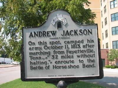
nscription. On this spot, camped his army, October 11, 1813, after marching from Fayetteville, Tenn.,~"32 miles without halting,"~ enroute to the Battle of Horseshoe Bend.
Erected 1951 by Erected by ACME Club, Huntsville.
Location. 34° 44.017′ N, 86° 35.062′ W. Marker is in Huntsville, Alabama, in Madison County. Marker is at the intersection of Holmes Avenue and Lincoln St., NE on Holmes Avenue.. Located in the triangle of Holmes Ave Ne, Lincoln St NE sign is facing Lincoln St. in the median. Marker is in this post office area: Huntsville AL 35801, United States of America.
Fort Bowyer
In the year 1813, on order of President Madison, Mobile Point
from Spain by U.S. Regulars, under Gen. James Wilkinson, and
militia, under Col. John Bowyer. A wood and earth stockade was
quickly built here. It was in the shape of a D and armed with
cannon taken from Fort Charlotte in Mobile. It’s mission
was to protect the entrance to Mobile Bay from the Gulf of Mexico.
Located on the east side of the entrance to Mobile Bay, Mobile
Point, Baldwin County Alabama, 30 miles south of Mobile, Alabama.
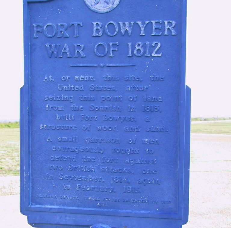
Inscription. At, or near, this site, the United States, after seizing this point of land from the Spanish in 1813, built Fort Bowyer, a structure of wood and sand. A small garrison of men courageously fought to defend the fort against two British attacks, one in September, 1814, again in February, 1815.
Erected 1972 by Alabama Society United States Daughters of 1812.
Fort St. Stephen
Established by the French about 1714, held afterwards by the
Spanish, who made a settlement there about 1786, given up by
the Spaniards to the Americans in 1799. Considered by the Creeks
impregnable.Located on the west bank of the Tombigbee River, on a high bluff,
Washington County, Alabama, about 67 miles north of Mobile, Alabama
.Fort Stoddart
Established by United States troops in July of 1799. This was
a Stockade and bastion type. Port of entry into the United States
where the Court of Admiralty was held. In 1804 Captain Schuyler
of New York was commander of the post of eighty men, Lt. Edmund
P. Gaines, Lt. Reuben Chamberlain paymaster. Duties were exacted
on imports and exports, (In 1807 Natchez, Mississippi planters
paid for Kentucky flour at $4.00 a barrel, the same flour brought
through Spanish Mobile, and brought up the river to Ft. Stoddart
cost the Tombigbee planters sixteen dollars a barrell. Located on the west bank of the Mobile River, Mobile County,
Alabama, four miles due east of Mount Vernon, Alabama and 30
miles north of Mobile, Alabama
.
Fort Charlotte (Fort Conde)
Fort Conde was a classic 18th century brick and mortar square
fort with large bastions on each corner, gunnery parapet, surrounding
moat and outer earthworks. Built in the early 1700's by Bienville,
the French founder of Mobile. When the English captured the fort
in 1763, the name was changed to Fort Charlotte in honor of George
III's Queen. Seventeen years later (1780) the Spanish took possession.
Located on the west bank of the Mobile River, Mobile County,
Alabama, in the city of Mobile, Alabama
.
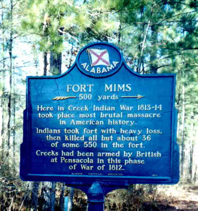
Fort Mims
Built in July 1813, as a wooden stockade, square in shape, enclosing
nearly an acre, with a protected blockhouse on the Southwest
corner, with two large gates- one on the west wall and the other
on the east wall. Stormed and taken by the Creeks on August 30,
1813.
Located 35 miles northeast of Mobile, Alabama, in Baldwin County,
Alabama, a ¼ quarter mile from the east bank of the Tensaw
River.
Fort Pierce
Small wooden stockade built by the Pierce brothers, William and
John of New England during the late 1700’s.
Located two miles southeast of Fort Mims.
Fort Glass and Fort Madison (Housed more than one thousand persons)
Fort Glass
Small wooden stockade built by Zachariah Glass and his neighbors.
It’s dimensions were 60 yards by 40 yards, rectangular
in shape. During August 1813 was occupied by Colonel Carson’s
Regiment of two hundred mounted men.
Located on the eastern boundary of Clarke County Alabama, 225
yards south of Fort Madison.
Fort Madison
Built around August 1813. During the Creek War was occupied by
settlers. Wooden stockade, square in shape, 60x60 yards, about
an acre of ground. A trench three feet in depth was dug around
the outside and the bodies of pine trees cut about fifteen feet
in length were placed perpendicularly in the trench side by side,
making thus a wall of pine wood twelve feet in height. Portholes
were cut at convenient distances so as to enable the defenders
to look out, and in case of an attack to fire upon the besiegers.
It was lighted at night by means of the abundant "pine-knot" placed
upon scaffolds, covered with earth, when used would light up
the area with a powerful white light.
Located in the center of a large Fort Madison neighborhood. First
store located due east, six miles on the Alabama River in 1812.
First gristmill located four miles north in 1812. First cotton
gin located two miles north in 1813. Surrounded by the first
plantations in the area.
Located about ten miles east of Jackson, Clarke County, and Alabama.
Six miles west of the Alabama River and ten miles east of Jackson,
Alabama. About 55 miles north of Mobile, Alabama. Exact location:
North-east corner of section one, township six, range three east
of the St. Stephens meridian, on the water-shed line, which was
then the eastern boundary of Clarke County.
Fort Sinquefield
A wooden stockade with a block-house built on a table-land or
height of ground extending for a mile north and south. Eastward
is a gentle slope which terminates finally in the Bassett’s
Creek Valley. Westward are deep valleys and narrow, between large,
high ridges of land. A spring supplied the fort with water is
to the southwest, in one of the deep valleys, 275 yards away.
The Creeks attacked this fort but was unable to take it.
Ninety feet distant from the stockade ground, in a northwest
direction, are some graves. A few yards eastward of the forts
location is supposed to be an old burial place, although the
graves were not distinct in 1879.
Located about ten miles north of Fort Madison, on the western
side of Bassett’s Creek, Clark County, Alabama. Exact location:
section thirteen, township eight, range three east. One mile
northeast of Whatley, Alabama and about 65 miles north of Mobile,
Alabama.
Fort White
A small wooden stockade built a short distance northeast of the
present Grove Hill, Clark County, Alabama.
Landrum’s Fort and Mott’s Fort
These two wooden stockades were located eleven miles west from
Fort Sinquefield; on section eighteen, township eight, range
two east. Clark County, Alabama.
Fort Easley
This stockade was built on a small plateau containing about three
acres. On the side next to the river the bluff is almost a perpendicular
wall, there is a large spring of water flowing from it’s
side. This steep plateau made the stockade a naturally strong
position.
Fort Mims
Fort Pierce
Small wooden stockade built by the Pierce brothers, William and
John of New England during the late 1700’s.
Located two miles southeast of Fort Mims.
Fort Glass and Fort Madison (Housed more than one thousand persons)
Fort Glass
Small wooden stockade built by Zachariah Glass and his neighbors.
It’s dimensions were 60 yards by 40 yards, rectangular
in shape. During August 1813 was occupied by Colonel Carson’s
Regiment of two hundred mounted men.
Located on the eastern boundary of Clarke County Alabama, 225
yards south of Fort Madison.
Fort Madison
Built around August 1813. During the Creek War was occupied by
settlers. Wooden stockade, square in shape, 60x60 yards, about
an acre of ground. A trench three feet in depth was dug around
the outside and the bodies of pine trees cut about fifteen feet
in length were placed perpendicularly in the trench side by side,
making thus a wall of pine wood twelve feet in height. Portholes
were cut at convenient distances so as to enable the defenders
to look out, and in case of an attack to fire upon the besiegers.
It was lighted at night by means of the abundant "pine-knot" placed
upon scaffolds, covered with earth, when used would light up
the area with a powerful white light.
Located in the center of a large Fort Madison neighborhood. First
store located due east, six miles on the Alabama River in 1812.
First gristmill located four miles north in 1812. First cotton
gin located two miles north in 1813. Surrounded by the first
plantations in the area.
Located about ten miles east of Jackson, Clarke County, and Alabama.
Six miles west of the Alabama River and ten miles east of Jackson,
Alabama. About 55 miles north of Mobile, Alabama. Exact location:
North-east corner of section one, township six, range three east
of the St. Stephens meridian, on the water-shed line, which was
then the eastern boundary of Clarke County.
Fort Sinquefield
A wooden stockade with a block-house built on a table-land or
height of ground extending for a mile north and south. Eastward
is a gentle slope which terminates finally in the Bassett’s
Creek Valley. Westward are deep valleys and narrow, between large,
high ridges of land. A spring supplied the fort with water is
to the southwest, in one of the deep valleys, 275 yards away.
The Creeks attacked this fort but was unable to take it.
Ninety feet distant from the stockade ground, in a northwest
direction, are some graves. A few yards eastward of the forts
location is supposed to be an old burial place, although the
graves were not distinct in 1879.
Located about ten miles north of Fort Madison, on the western
side of Bassett’s Creek, Clark County, Alabama. Exact location:
section thirteen, township eight, range three east. One mile
northeast of Whatley, Alabama and about 65 miles north of Mobile,
Alabama.
Fort White
A small wooden stockade built a short distance northeast of the
present Grove Hill, Clark County, Alabama.
Landrum’s Fort and Mott’s Fort
These two wooden stockades were located eleven miles west from
Fort Sinquefield; on section eighteen, township eight, range
two east. Clark County, Alabama.
Fort Easley
This stockade was built on a small plateau containing about three
acres. On the side next to the river the bluff is almost a perpendicular
wall, there is a large spring of water flowing from it’s
side. This steep plateau made the stockade a naturally strong
position.
General Claiborne had visited the fort at the end of August,
1813 on reports that the Creeks were going to attack it. This
put his command about sixty miles from the real target Fort Mims.
Located on the east bank of the Tombigbee River, eighty miles
north of Mobile, Alabama, and five miles west of Campbell, Clarke
County, Alabama. The exact location is on section ten or eleven,
township eleven, range one west.
Turner’s Fort
This fort was built of split pine logs doubled and contained
two or three block-houses. The Turner, Thornton, Pace and other
families used this fort for protection.
Located eight miles south and five miles west of Fort Easley,
in the West Bend Community two miles east of the Tombigbee River
near the residence of Abner Turner, or about 72 miles north of
Mobile, Alabama. Three miles distant, on the Tombigbee River
was the Choctaw reservation known as Turkey Town.
Cato’s Fort
Located on the west side of the Tombigbee River, five miles below
Coffeeville, about a mile from the river.
Rankin’s Fort (housed about five hundred and thirty people)
This was a large wooden stockade and the most Western of the
river group of forts.
Located in Washington County, Alabama.
McGrew’s Fort
This wooden stockade enclosed nearly two acres. Some of the palisades
post were still in place as late as 1879, and around the fort
locality was an old field. Here two brothers, William McGrew
and John McGrew, British royalists and refugees, made an early
settlement near the Tombigbee River. McGrew’s Reserve,
an old Spanish grant, was a landmark in Clarke County for many
years. They were known to have become exemplary Americans.
Located in the corner of section one, township seven, range one
west, about three miles north of Fort St. Stephens, in Clark
County, Alabama; five miles north and eighteen west from Fort
Madison.
Fort Carney (housed about four hundred people)
Built by Josiah Carney, who settled on the River in 1809.
Located six miles south from Jackson, Alabama, in Clarke County,
at Gullet’s Bluff (now called Carney Bluff), on the line
of travel to Mount Vernon, Alabama.
Powell’s Fort
Three miles south of Fort Carney, near Oven Bluff, was Powell’s
Fort, where about six families, including those of John McCaskey,
James Powell, and John Powell.
Lavier’s Fort
Built near the residence of Captain Lawson Lavier, who traded
with the Choctaw Indians. Location not known
Mount Vernon
Headquarters for General Claiborne. Two Stockade forts were located
here.Located 29 miles north of Mobile, Alabama in Mobile County.
Patton’s Fort
Located at Winchester, Wayne County, Mississippi.
Roger’s Fort
Located six miles north of Patton’s Fort in Wayne County,
Mississippi.
Fort Montgomery
Built in the fall of 1814 by Colonel Thomas H. Benton. This was
the staging and assembly area for General Jackson’s army
for the attack on Spanish Pensacola, Florida.
Located two miles north of Fort Mims site. Located 37 miles northeast
of Mobile, Alabama, in Baldwin County, Alabama, near the east
bank of the Tensaw River.
Fort Strother
Built by General Andrew Jackson in October of 1813 as an advanced
supply base.
Located at the junction of the Coosa River and Canoe Creek in
St. Clair County Alabama on the east end of Hines Mountain, about
ten miles southwest of the present city of Gadsden, Alabama.
Fort Deposit
Built by General Andrew Jackson in September 1813 as a main base
for his army.Located at the southern most point of the Tennessee
River in Marshall County, Alabama near the present city of Guntersville,
Alabama.
Fort Claiborne
Built by General Claiborne in mid October, 1813 in ten days.
A wooden stockade, two hundred feet square, defended by three
block-houses and a half moon battery which commanded the river.
Used as a staging area for the Battle of Holy Ground.
Located on the east side of the Alabama River at Weatherford’s
Bluff, Claiborne, Monroe County, Alabama; thirty-five miles north
of Fort Mims.
Pensacola Fort System, Florida
Fort San Miguel. Taken over, with Spanish consent, by the British
in 1812 - 1814, renamed Fort St. Michael. Briefly captured by
Americans in 1814. Nearby at Spring and Brainard Streets, 600
yards north, was British Crescent Redoubt (1778 - 1781), also
known as Queen's Redoubt.
Fort George. A British fort once located in downtown Pensacola
at Palafox and LaRua Streets (now a city park) on Palafox (Gage)
Hill. Fort Waldeck at Seville Square was part of Fort George
until named seperately in 1781. Captured by the Spanish in 1781,
rebuilt in 1783 and renamed Fort San Bernardo (aka St. Bernard).
Abandoned in 1821. British Prince of Wales Redoubt (aka Middle
Redoubt) (1780) was located at Cerevantes and Spring Streets
on Gage Hill. Captured by Spain in 1781 and renamed Fort Sombrero
. British Pensacola Barracks (1778 - 1781), with two two-story
blockhouses, was located at Zarragosa and Tarragona Streets (behind
present-day Pensacola Historical Society). One building burned
down before 1813, the other was destroyed in 1820.
Fort Barrancas System, Florida
Fort San Carlos de Barrancas, a log and earthen work, was located
within remains of an old British redoubt called Royal Navy Redoubt
(1780 - 1781). The Spanish also built the brick and mortar Bateria
de San Antonio (1796), a semi-circular, water-level battery with
seven mounted guns and a bomb-proof magazine, and a shelter for
150 soldiers, located below and south of Fort San Carlos de Barrancas.
The British returned again in 1796 and occupied the fort until
1814, when the Americans destroyed the wooden Fort San Carlos
de Barrancas after defeating the British. Bateria de San Antonio
survived and is sometimes referred to today as The Water Battery.
Fort Santa Rosa, Santa Rosa Island, Florida
Fort Santa Rosa. An old Spanish fort located near Point Siguenza,
near where Fort Pickens was later built. It was destroyed by
a hurricane in 1752. Rebuilt later by the British. Renamed Fort
St. Rose or St. Rose Battery by the British, and later American
troops in 1814.
British Post (Later Negro Fort, and Fort Gadsden ) located in
Spanish Territory , later Franklin County, Florida, 27 miles
north of the Apalachicola River mouth, east bank. In 1814 Brevet
Major (local rank Lt. Colonel) Edward Nicholls of the Royal Marines
with British soldiers and the black and Indian recruits constructed
a fort 500 feet from the river bank on Prospect Bluff, which
they called British Post. Consisting of an octagonal earthwork
holding the principal magazine and surrounded by an extensive
rectangular enclosure covering about seven acres with bastions
on the eastern corners having parapets 15 feet high and 18 feet
thick, the fort was used as the British headquarters for negotiations
between the black and Indian communities. In 1815 when the British
withdrew from the area, the fort, including its artillery and
military supplies, were given to the many blacks and a few Indians
that had moved into it, seeking the protection it offered and
cultivating successful and profitable plantations around it
FORT STODDERT
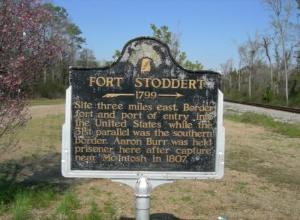
Fort Stoddert was established in 1799 on the Mobile River near the boundary between the Mississippi Territory and Spanish West Florida. The fort was for a time a port of entry to the United States Territory, but is most well known as the western terminus of the Federal Road connecting central Georgia with the Tenesaw District. The Fort, along with the nearby post at Mount Vernon, served as the central command center for military actions in the Tensaw Region during the Creek War, as well as the place of refuge for settlers who fled the area in the wak of the attack on Fort Mims. A historic marker commemorating Fort Stoddert stands alongside Highway 43 in the area of the communities of Mount Vernon and Fort Stoddert in northern Mobile County, Alabama. The actual fort site, now a landing on the Mobile River, is located three miles eat of the marker and is unmarked.
.Fort Stoddertwas
a Stockade of thebastion type intended to protect the port of entry into the United States
where the Court of Admiralty was held. In 1804 Captain Schuyler
of New York was commander of the post of eighty men, Lt. Edmund
P. Gaines, Lt. Reuben Chamberlain paymaster. Duties were exacted
on imports and exports, (In 1807 Natchez, Mississippi planters
paid for Kentucky flour at $4.00 a barrel, the same flour brought
through Spanish Mobile, and brought up the river to Ft. Stoddart
cost the Tombigbee planters sixteen dollars a barrel.)
Battle of New Orleans Song Lyrics
Well, in eighteen and fourteen we took a little
trip
along with Colonel Jackson down the mighty Mississip.
We took a little bacon and we took a little beans,
And we caught the bloody British near the town of New Orleans.
We fired our guns and the British kept a'comin.
There wasn't nigh as many as there was a while ago.
We fired once more and they began to runnin'
down the Mississippi to the Gulf of Mexico.
Well, I see'd Mars Jackson walkin down the street
talkin' to a pirate by the name of Jean Lafayette [pronounced La-feet]
He gave Jean a drink that he brung from Tennessee
and the pirate said he'd help us drive the British in the sea.
The French said Andrew, you'd better run,
for Packingham's a comin' with a bullet in his gun.
Old Hickory said he didn't give a dang,
he's gonna whip the britches off of Colonel Packingham.
We fired our guns and the British kept a'comin.
There wasn't nigh as many as there was a while ago.
We fired once more and they began to runnin'
down the Mississippi to the Gulf of Mexico.
Well, we looked down the river and we see'd the British come,
and there must have been a hundred of 'em beatin' on the drum.
They stepped so high and they made their bugles ring
while we stood by our cotton bales and didn't say a thing.
Old Hickory said we could take 'em by surprise
if we didn't fire a musket til we looked 'em in the eyes.
We held our fire til we see'd their faces well,
then we opened up with squirrel guns and really gave a yell.
We fired our guns and the British kept a'comin.
There wasn't nigh as many as there was a while ago.
We fired once more and they began to runnin'
down the Mississippi to the Gulf of Mexico.
Well, we fired our cannon til the barrel melted down,
so we grabbed an alligator and we fought another round.
We filled his head with cannon balls and powdered his behind,
and when they tetched the powder off, the gator lost his mind.
We'll march back home but we'll never be content
till we make Old Hickory the people's President.
And every time we think about the bacon and the beans,
we'll think about the fun we had way down in New Orleans.
We fired our guns and the British kept a'comin,
But there wasn't nigh as many as there was a while ago.
We fired once more and they began to runnin'
down the Mississippi to the Gulf of Mexico.
Well, they ran through the briars and they ran through the
brambles
And they ran through the bushes where a rabbit couldn't go.
They ran so fast the hounds couldn't catch 'em
down the Mississippi to the Gulf of Mexico.
We fired our guns and the British kept a'comin.
But there wasn't nigh as many as there was a while ago.
We fired once more and they began to runnin'
down the Mississippi to the Gulf of Mexico.